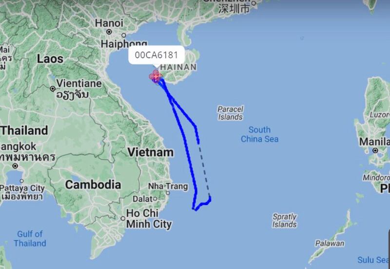
A Chinese military drone flew close to Vietnam’s coast early on Wednesday, the second known such incident this month, according to publicly available tracking data.
Data provided by Flightradar24, a Swedish flight tracker, shows that a Wing Loong-10 unmanned aerial vehicle, or UAV, flew from China’s Hainan island into space over Vietnam’s exclusive economic zone (EEZ). It followed a path along the coastline for about 800 kilometers (500 miles) before turning around near Phan Rang province.
Using the call sign 00CA6181 and HEX code 783132, the drone is likely the WZ-10 unmanned aircraft that was reportedly spotted on Aug. 2, also close to Vietnam's coast.
A HEX code, also called a ICAO 24-bit address, is a unique identification number given by the International Civil Aviation Organization, and is different for every aircraft.
At some point, the WZ-10 was 160 km-170 km (100-106 miles) from Cam Ranh, a strategic deep-water seaport and an important Vietnam’s naval base.

An EEZ is a maritime area measured 200 nautical miles (370 km) from a country’s coast. The space above it is international space but part of it falls within Ho Chi Minh City’s flight information region where Vietnam provides flight information service.
The Vietnamese government has not made any comment on the recent Chinese drone sightings.
Radio Free Asia was not immediately able to contact relevant Chinese authorities for comment. It was also not able to determine if China had flown such UAVs near Vietnam before this month.
A Vietnamese coast guard ship is in Manila this week and is expected to conduct the first-ever joint drills with the Philippine coast guard on Friday. Both countries have territorial disputes with China in the South China Sea, the vast majority of which Beijing claims.
RELATED STORIES
[ Vietnam’s coast guard to hold first drills with PhilippinesOpens in new window ]
[ Chinese drones now almost a daily appearance over TaiwanOpens in new window ]
[ Chinese strike drone flies near Taiwan as island stages military drillsOpens in new window ]
Reconnaissance drone
The WZ-10 is a high-altitude, long-endurance UAV developed by Chengdu Aircraft Design and Research Institute for reconnaissance purposes. It’s said to have a wingspan of about 20 meters (65 feet), a length of about 9 meters (30 feet), and a height of approximately 4 meters (13 feet).
The WZ-10 is believed to be able to operate at altitudes up to 49,000 feet (14,900 meters) – much higher than commercial aircraft - with a flight time of 20 hours at a cruising speed of 330 knots.
On May 27, the Japanese defense ministry said that the Japan Air Self-Defence Force intercepted a WZ-10 UAV from China flying near Okinawa for the first time amid rising tension between the neighbors in the East China Sea.
“The WZ-10 is an unmanned combat aerial vehicle, so potentially it can carry missiles,” said Jyh-Shyang Sheu, a military expert at Taiwan's Institute for National Defense and Security Research.
“The deployment of such a drone can be for both reconnaissance and political purposes, perhaps to give some warnings or coercion signals,” Sheu said, “China always shows its muscles to neighbors and UAVs can be used as a tool for gray zone tactics.”
Gray zone warfare is not an act of war but a means to coerce that is harmful to the security of the target country.
The Chinese military has flown reconnaissance and strike drones near Taiwan in the past. In September 2022, China sent UAVs almost every day to Kinmen island in the Taiwan Strait.
Sheu said the drones sent to Taiwan were of different types and China, one of the largest drone manufacturers in the world, is increasingly using them.
Editing by Taejun Kang.
